Just after leaving Hobby, I stopped at Weiser...
| Houston Hobby To Pinckneyville-Du Quoin |
|---|
This trip was one of many firsts. It would be the first time I had met the people of the rec.aviation newsgroups for real, the longest cross country to date, the first solo experience with a primary class B airport and the first flight in a Cheetah. See also my planning the trip section for how I planned the trip which covered three sectionals (going in a North/South direction just to add the task of having to use both sides of the charts).
| Everything is coming unravelled... |
|---|
I've never planned to go on a trip as far in advance as I had this one. The date of the Pinckneyville Rec.Aviation flyin was known a long time in advance. To make sure I had a plane for the trip, and even better than that a taildragger, I got on the club schedule two months before the trip and reserved the Cessna 170 for a long weekend. I was looking forward to this. It was going to be perfect I thought. The first fly in the ointment was when the 170 went for its 100-hour a month before my trip. The mechanic found metal shavings in the oil screen, so there was nothing for it but an engine rebuild. Everyone expected it to take less than a month, but... on the Monday before I was due to leave, I called the mechanic (who is also a half owner of the aircraft) who had the bad news that it wouldn't be ready by the weekend. Not only that, but it wouldn't be ready until some time in June! I cursed myself for not immediately reserving the Arrow or the 172 as soon as the 170 went in for maintenance. The same thing had happened to the 172 when I was a student pilot so I should have seen it coming.
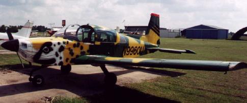
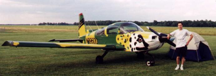
All the other club planes were already booked. The 172 was the least booked, so at the same time as calling FBO's for alternatives, I asked the two people who had booked the 172 on the Saturday whether they'd do me a massive favor and let me have the plane for the weekend. Fortunately, I didn't have to take them up on the offer, as Fletcher Aviation at Houston Hobby had a Grumman Cheetah available all weekend. Not only that, but a camoflague painted Cheetah! So although I would now be landing in a nosedragger, at least it would be an interesting one.
So I got checked out in the Grumman AA5 series by flying the Tiger at Fletcher in preparation for the trip, only two days before the trip. Fortunately, everything went smoothly, and I discovered that the Grumman AA5 was a superb flying aircraft. Now I had a plane for the trip, I was all set...but of course the weather started turning crummy! A front was going to go right over the route of flight, bringing some quite nasty storms. Friday morning, as I got ready to leave, it looked like I would be spending the night in Arkansas, or maybe not even getting that far.
| On my way |
|---|
I arrived at 9:30 am on Friday morning at Fletcher to pick up the Cheetah and go. I felt undaunted by the fact that this was the first time I had soloed from a Class B primary airport since it didn't seem too busy whilst I preflighted. I've flown into Class C airports a few times, and Class B airports are pretty much the same, just busier. I'd also been shown the ropes when I got checked out. Somehow I managed to sound professional on the radio when calling clearance and remembered to say I had information Victor (I'm always forgetting to tell them I've received ATIS!) and I was soon taxiing out for an intersection takeoff on 12R from taxiway Kilo. However, when I called Tower with "ready for departure", they had different plans. They initially had me hold for 12R, then due to the number of incoming airliners (it suddenly got busy just as I got moving), had me cross 12R, take a quick left and do an intersection takeoff off 22L from taxiway Mike. Off I went towards Weiser Air Park to meet Tina and Michael. Weiser is only about 15 minutes north west of Hobby, so departure soon let me loose. I landed and parked on a vacant tie down spot and looked for Tina and Michael. They weren't there. Ten minutes later they still weren't there, so I decided to call. The conversation went something like this:
"Hi Michael, it's Dylan here, you ready to fly to Pinckneyville?"
"What are you talking about! It's next weekend!"
For a horrible moment, I got the cold tinglies and thought I was a week early. However, I was right...but it meant Tina and Michael wouldn't be able to go at such short notice. Oh well, there's always next year!
After this setback, I decided to check the weather and see what the progress of this cold front was. It was at least looking better - it had moved on, and I should be able to get as far as Pine Bluff, Arkansas. I took off from Weiser, and started my long journey northwards.
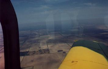
At this point I discovered that the single VOR receiver had pretty much died, and that the LORAN was pretty user hostile. The quick reference guide I read on the ground at Weiser hadn't helped me a lot, so I just turned the thing off. Since I had a dead-reckoning VFR direct flight plan, it didn't really matter anyway. The only electrical navaid I needed was my digital kitchen timer, stuck to my yoke clip. I skirted around Hooks Meml. Class D airspace, then turned on course and pressed "Start" on my timer, for what would be the first in many pressings of Start and Reset. Very rapidly I was over the piney woods of east Texas. This really is dead reckoning land, since the landmarks are widely spaced. Fortunately, they are big and easy to spot, even with the haze that was present as I left. First came Conroe airport, then Lake Livingston, the Sam Rayburn resevoir, then the humungous Toledo Bend resevoir which is over 60NM long. That one's a bit hard to miss! My checkpoints were all coming up earlier than expected, so I had a tail wind. I felt pleased, I was on course at each checkpoint, and they were all 30 miles apart.
 Recalling the weather I had looked at when I was stopped in
Weiser, I kept my airport guide open to the next airport near my route
all the time. I was approaching the Arkansas border after crossing the
northwestern corner of Louisiana.
Recalling the weather I had looked at when I was stopped in
Weiser, I kept my airport guide open to the next airport near my route
all the time. I was approaching the Arkansas border after crossing the
northwestern corner of Louisiana.
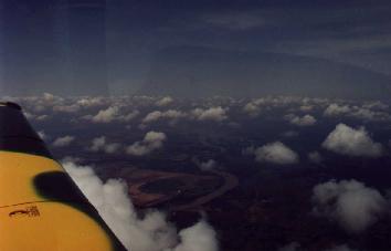
Passing over the Red River in Louisiana, I could see no sign of frontal
activity, which was at least good. About half an hour later, I could see the
front. However, I was now feeling optimistic. Instead of a wall of cloud ahead,
the wall of cloud was a good fifteen to twenty miles to the east. It looked
like I'd stay behind the bad weather. A short while later, I actually
penetrated the front, but although the weather looked foreboding to the
east, in my direction of flight the worst weather was a scattered layer at
around 4,000 ft. and overcast cirrus above, and lowered visibility in haze.
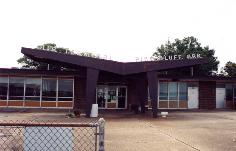
A little later, I made my planned fuel stop, Grider field in Pine Bluff, Ark.
It was interesting to see a crop-sprayer hugging the earth below me as I
entered the pattern for Grider runway 17. The Arkansas River meandered to
my north. I landed, and taxied in. Nothing was happening, apart from
a lone man using a pair of wheelchocks to marshal me towards the fuel truck.
 It seemed like the people in this rural area of Arkansas were quite shy,
unlike Texans. After my prop stoped, the line man came up to my aircraft,
and I asked for a top off. Wordlessly, he started up the fuel truck, and
rolled up to the plane to fuel it, and wordlessly, he filled it up.
In the meantime, I took in the scene. Grider looks like it's frozen in
the 1950's.
It seemed like the people in this rural area of Arkansas were quite shy,
unlike Texans. After my prop stoped, the line man came up to my aircraft,
and I asked for a top off. Wordlessly, he started up the fuel truck, and
rolled up to the plane to fuel it, and wordlessly, he filled it up.
In the meantime, I took in the scene. Grider looks like it's frozen in
the 1950's.
 The terminal building most definitely gave the whole place that 1950's
aura. The only thing that betrayed this was my Grumman and a couple of
helicopters. All the other aircraft on the field wouldn't have looked
out of place in the 50's. I went in to pay my fuel bill. Wordlessly, the
airport manager, a lady in her 50's filled out the credit card receipt.
I asked her about the restaurant. Unfortunately, I had missed the restaurant
by about 15 minutes, and I was hungry after 3 hours of flying! Well,
there was nothing for it, go for the food simulators (aka vending machines).
A snickers bar and a can of Coke had me somewhat restored. I also got
some emergency rations - a pack of Lay's barbecue flavor chips just in
case I got peckish between here and Pinckneyville! At this point, a helicopter
pilot came in, and I struck up a conversation. I asked him if he'd encountered
any weather to the north, and he said it was clear as far as he could see.
I called WX-BRIEF to see what was going on nearer Illinois, and it seemed
pretty clear. There was some widely scattered thunderstorms near St. Louis,
but that was about it. I realised that I would be able to make it today.
Grider didn't have a weather computer, so I couldn't get a visual check
on the front's progress which I would have liked since I can form a better
picture of the weather than from just a verbal description of the weather.
I went out, did a walk-around of the plane to check everything was still
properly attached, made sure the fuel was good and the oil was at the
right level, then taxied out, and was gone. The majority of the aircraft
parked at Grider that I passed as I taxied back to 17 were ag-planes,
various mono and biplanes and a few helicopters with spraying equipment
attached.
The terminal building most definitely gave the whole place that 1950's
aura. The only thing that betrayed this was my Grumman and a couple of
helicopters. All the other aircraft on the field wouldn't have looked
out of place in the 50's. I went in to pay my fuel bill. Wordlessly, the
airport manager, a lady in her 50's filled out the credit card receipt.
I asked her about the restaurant. Unfortunately, I had missed the restaurant
by about 15 minutes, and I was hungry after 3 hours of flying! Well,
there was nothing for it, go for the food simulators (aka vending machines).
A snickers bar and a can of Coke had me somewhat restored. I also got
some emergency rations - a pack of Lay's barbecue flavor chips just in
case I got peckish between here and Pinckneyville! At this point, a helicopter
pilot came in, and I struck up a conversation. I asked him if he'd encountered
any weather to the north, and he said it was clear as far as he could see.
I called WX-BRIEF to see what was going on nearer Illinois, and it seemed
pretty clear. There was some widely scattered thunderstorms near St. Louis,
but that was about it. I realised that I would be able to make it today.
Grider didn't have a weather computer, so I couldn't get a visual check
on the front's progress which I would have liked since I can form a better
picture of the weather than from just a verbal description of the weather.
I went out, did a walk-around of the plane to check everything was still
properly attached, made sure the fuel was good and the oil was at the
right level, then taxied out, and was gone. The majority of the aircraft
parked at Grider that I passed as I taxied back to 17 were ag-planes,
various mono and biplanes and a few helicopters with spraying equipment
attached.
As I crossed the Arkansas River, I noticed that the landscape
had abruptly changed from the tractless void of piney woods I had been
crossing to open farmland. I also noticed that all the male voices on
the radio sounded just like Bill Clinton. Having never travelled in Arkansas
before, I hadn't realised that they really all spoke like that!
 The sky had also cleared up, and with the exception of some scattered cirrus
and scattered altocumulus, it was clear. There were occasional small
flat sheets of cloud that seem to always accompany the passing of a front.
It was a beautiful sight, and I was thoroughly enjoying myself, glad I
wasn't driving. To experience the United States properly, it has to be
done by the air. My dead reckoning was going pretty much perfectly
and I was enjoying my VFR duties of keeping a good lookout. It seemed
odd, but for some reason, my checkpoints (still reasonably widely spaced)
were coming up several minutes ahead of schedule. The tailwind couldn't
be that strong, I thought. After passing the second checkpoint on the
northern side of the Memphis sectional I was getting mighty suspicious.
I pulled out my plotter from my bag, and slapped it down on the map.
My suspicions were confirmed: I had made a monumental flight planning
boob and had accidentally used the Statute mile side of the plotter
instead of the Nautical mile side when measuring out the route! I remeasured
the remaining checkpoint distances on the Memphis sectional and quickly
recomputed the ETE's between the points with the trusty metal E6B.
I also checked my St. Louis chart, but found I had measured those correctly.
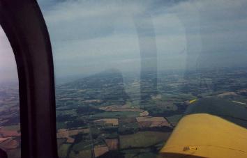
As I entered south east Missouri, the landscape had once again been changing,
but this time more slowly and subtly. Open farmland was giving way to
a patchwork of woodlands and smaller irregular shaped fields, a sure sign of
livestock farming rather than arable crops. It was also becoming gently
undulating, and really quite similar to southeastern England.
The sky had also cleared up, and with the exception of some scattered cirrus
and scattered altocumulus, it was clear. There were occasional small
flat sheets of cloud that seem to always accompany the passing of a front.
It was a beautiful sight, and I was thoroughly enjoying myself, glad I
wasn't driving. To experience the United States properly, it has to be
done by the air. My dead reckoning was going pretty much perfectly
and I was enjoying my VFR duties of keeping a good lookout. It seemed
odd, but for some reason, my checkpoints (still reasonably widely spaced)
were coming up several minutes ahead of schedule. The tailwind couldn't
be that strong, I thought. After passing the second checkpoint on the
northern side of the Memphis sectional I was getting mighty suspicious.
I pulled out my plotter from my bag, and slapped it down on the map.
My suspicions were confirmed: I had made a monumental flight planning
boob and had accidentally used the Statute mile side of the plotter
instead of the Nautical mile side when measuring out the route! I remeasured
the remaining checkpoint distances on the Memphis sectional and quickly
recomputed the ETE's between the points with the trusty metal E6B.
I also checked my St. Louis chart, but found I had measured those correctly.
As I entered south east Missouri, the landscape had once again been changing,
but this time more slowly and subtly. Open farmland was giving way to
a patchwork of woodlands and smaller irregular shaped fields, a sure sign of
livestock farming rather than arable crops. It was also becoming gently
undulating, and really quite similar to southeastern England.
 I was now less than an hour from my goal, Pinckneyville-Du Quoin airport.
I reminded myself that weather can still turn sour in that distance, so
to keep myself prepared. However, the weather continued to get clearer as
I pressed on northeastwards. I tuned in Cape Giradeau's automated weather
to see what lay ahead, and the ASOS weather was reporting clear below
12,000 feet. That's quite alright I thought! (I also learned how to
pronounce Cape Giradeau as well.) I listened to Cape Giradeau's tower frequency
to see what was going on there. It was completely quiet. I think I only
heard one flight in about half an hour. I guess it wasn't their rush-hour!
The landscape became greener as I continued, looking quite lush compared
to anywhere I've seen in Texas or had passed over. In the distance, I
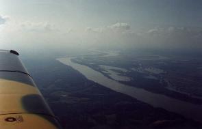
could make out the Mississippi river separating Missouri from Illinois,
as Cape Giradeau itself slid past my port side, some fifteen miles to
the east. Tuning into PJY's CTAF, I could already hear some fly-in traffic.
I was now less than an hour from my goal, Pinckneyville-Du Quoin airport.
I reminded myself that weather can still turn sour in that distance, so
to keep myself prepared. However, the weather continued to get clearer as
I pressed on northeastwards. I tuned in Cape Giradeau's automated weather
to see what lay ahead, and the ASOS weather was reporting clear below
12,000 feet. That's quite alright I thought! (I also learned how to
pronounce Cape Giradeau as well.) I listened to Cape Giradeau's tower frequency
to see what was going on there. It was completely quiet. I think I only
heard one flight in about half an hour. I guess it wasn't their rush-hour!
The landscape became greener as I continued, looking quite lush compared
to anywhere I've seen in Texas or had passed over. In the distance, I
could make out the Mississippi river separating Missouri from Illinois,
as Cape Giradeau itself slid past my port side, some fifteen miles to
the east. Tuning into PJY's CTAF, I could already hear some fly-in traffic.
 As I passed the Mississippi river, I was now about fifteen minutes from
landing. A little while later, I called in for the fly-in, and overflew
the airport at pattern height + 500 feet, and looped back for a 45-degree
entry to downwind for 18. I managed to get a nice landing in (which is
a good thing when you're going to a fly-in, because you know that
everyone is watching and grading your landing! I taxied in past the
welcoming committee, and John Johnson, being chief Parking John,
marshalled me to a convenient parking spot. My camo Grumman had already
brought awe to the crowd (phrases such as "what the hell is *that*?" had
been uttered as I had flown overhead, oh well!
As I passed the Mississippi river, I was now about fifteen minutes from
landing. A little while later, I called in for the fly-in, and overflew
the airport at pattern height + 500 feet, and looped back for a 45-degree
entry to downwind for 18. I managed to get a nice landing in (which is
a good thing when you're going to a fly-in, because you know that
everyone is watching and grading your landing! I taxied in past the
welcoming committee, and John Johnson, being chief Parking John,
marshalled me to a convenient parking spot. My camo Grumman had already
brought awe to the crowd (phrases such as "what the hell is *that*?" had
been uttered as I had flown overhead, oh well!
I had now completed my longest cross country, all by dead
reckoning and pilotage. Not only that, if I ever decide to go for the
commercial rating, I've got the long solo cross country requirement done!
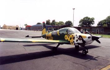
[The Ilk at P'ville]
[Aircraft at P'ville]
[Back to Flying]
[Home page]