|
THESE MIST-COVERED MOUNTAINS |
 Friday 13th is a day which superstitious people feel bodes badly.
For me, Friday 13th April 2001 was my first ever mountain flying.
I'm a flatlander, having never flown from an airport above about 2000 ft.
elevation, and of course, I've never seen mountains from the air. January
of 2001 was the first time in my life I had seen the Rocky Mountains (and that
was in a Volkswagen Jetta TDi!)
Friday 13th is a day which superstitious people feel bodes badly.
For me, Friday 13th April 2001 was my first ever mountain flying.
I'm a flatlander, having never flown from an airport above about 2000 ft.
elevation, and of course, I've never seen mountains from the air. January
of 2001 was the first time in my life I had seen the Rocky Mountains (and that
was in a Volkswagen Jetta TDi!)
Our flight was from Houston Gulf to Salt Lake City Muni #2,
just south of SLC's big airport. I flew with my friend Paul Reinman who
was in the process of moving to SLC. His wife, Jenny, had already found
work and a house there. If you've looked around my site, you'll have seen
my partners-in-crime: Paul and Jenny are the partners on my Cessna 140.
This long trip started early. Paul has a thing for early morning flying,
so he managed to badger me into going in for a 4am takeoff from Houston
Gulf.
Paul was working on his instrument rating, so I let him do the
flight planning. Our plan was to fly IFR to get out of Texas, then VFR
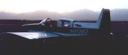
the rest of the way. We would be flying the club's Grumman Tiger, which
(after the C140 of course!) is one of my favorite aircraft. The weather
gods were also smiling on us: the weather would be soupy around Texas, but
a large area of high pressure was moving towards SLC promising settled
weather and light winds over the high country. I wanted the easiest flying
conditions since it was my first flight into rugged terrain - and we
got it!
Our 4am start went smoothly, and I racked up another 2 hours
of actual instrument time. We had a minor hitch as we approached our
first stop, Midland. The weather wasn't quite as forecast - instead of
an easy approach, they had 100 foot ceilings. We checked the weather for
other nearby airports: we had just passed San Angelo which had 600 foot
ceilings, but we found that Abilene had 3,500 ft. scattered. We told
Center we'd divert to Abilene. Looking at the charts some more, we found
that Sweetwater might be better - it was less flying distance and less
off course. The clouds were breaking up below us, so we told Center we'd
go to Sweetwater. They approved this. Ten miles out, the clouds were pretty
much all gone, and Sweetwater's ASOS was reporting 5 miles visibility and
clear skies. Ten miles out I canceled IFR and started setting up to enter
Sweetwater's pattern.
However, Murphy was at it again. We got to Sweetwater, and
the undercast had built up again! It just wasn't quite thick enough
for the ASOS to see. The highway just to the south of Sweetwater was visible,
but the airport itself was under a cloud deck with a 200 foot base!
However, all was not lost. The wind was out the south, and the clear skies
were to the south - about 1/4 of a mile to the south of the airport to be
precise. I pulled the power back, and we loitered for a bit whilst the cloud
deck blew away. After blowing my first landing and going around (I came in
too high in my haste to get in), we touched down at Sweetwater.
Our next stop was Albuquerque's Double Eagle airport. Not long
after passing Midland, the clouds broke up and we were in the clear. The
terrain became desert, and eventually the mountains around Albuquerque
loomed into view. We climbed up and over them. The view was breathtaking -
over the mountains with the city below. Airliners taking off from ABQ
seemed to be all aimed for a valley between the mountains, and from our
vantage point at over 10,000 feet MSL (but not many AGL) we could watch
Southwest's Boeing 737s departing. Approach control cleared us right
over Albuquerque's main airport as we headed for Double Eagle - the highest
airport I have ever flown into.
 After lunch and a refuel, we departed from Double Eagle for
our last leg to Salt Lake City. I was careful to lean for best power during
the run-up, since the density altitude was above 6,000 feet. Even though
the density altitude wasn't horrendously high, the difference between
this and our takeoff at Houston was obvious. The Tiger still performed
well, and we ran into some good thermals too, which boosted our climb rate.
The terrain was dotted with mesas, and mountains began to appear on the
horizon as we continued northwestwards towards our destination. The landscape
was remote and beautiful. I kept eyeing any sign of civilization, because
it would be where I'd try and head if we had any kind of emergency.
Over Farmington, we listened to their tower - it was about the only large
settlement we passed, and we were curious to see exactly how much traffic
they got. We were just in time to hear some real trouble involving a
Cherokee, his NORDO friend and a highly frustrated tower controller.
The tower was handling about 3 aircraft when a Cherokee called for landing.
He said he was to the northwest. Well, in fact (as he revealed later) he
was actually to the northeast. Not only could he not tell his east from
west, he couldn't tell his left from right either. To add to the confusion,
he had a friend who's radio had failed following him. The tower decided
to handle them as a flight of two.
The Cherokee reported right base as
requested, but it turned out he was left base for a completely different
runway - a runway for which a Bonanza was alread on final for! The Bonanza
pilot told the tower that someone had just cut in front. The tower controller
got a bit confused at this point, and you could hear the stress level rise
in his voice. He had the Bonanza pilot orbit while he got his troublesome
Cherokee sorted out. Not surprisingly, the Cherokee got asked to call
the tower on landing!
After lunch and a refuel, we departed from Double Eagle for
our last leg to Salt Lake City. I was careful to lean for best power during
the run-up, since the density altitude was above 6,000 feet. Even though
the density altitude wasn't horrendously high, the difference between
this and our takeoff at Houston was obvious. The Tiger still performed
well, and we ran into some good thermals too, which boosted our climb rate.
The terrain was dotted with mesas, and mountains began to appear on the
horizon as we continued northwestwards towards our destination. The landscape
was remote and beautiful. I kept eyeing any sign of civilization, because
it would be where I'd try and head if we had any kind of emergency.
Over Farmington, we listened to their tower - it was about the only large
settlement we passed, and we were curious to see exactly how much traffic
they got. We were just in time to hear some real trouble involving a
Cherokee, his NORDO friend and a highly frustrated tower controller.
The tower was handling about 3 aircraft when a Cherokee called for landing.
He said he was to the northwest. Well, in fact (as he revealed later) he
was actually to the northeast. Not only could he not tell his east from
west, he couldn't tell his left from right either. To add to the confusion,
he had a friend who's radio had failed following him. The tower decided
to handle them as a flight of two.
The Cherokee reported right base as
requested, but it turned out he was left base for a completely different
runway - a runway for which a Bonanza was alread on final for! The Bonanza
pilot told the tower that someone had just cut in front. The tower controller
got a bit confused at this point, and you could hear the stress level rise
in his voice. He had the Bonanza pilot orbit while he got his troublesome
Cherokee sorted out. Not surprisingly, the Cherokee got asked to call
the tower on landing!
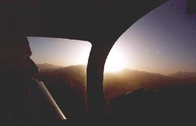
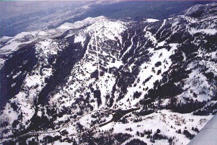
 It wasn't long after this that we started getting over really
high ground - over mountains themselves rather than just flying near them.
The view was breathtakingly beautiful, as we detoured slightly, overflying
the Alta and Brighton (photo above right) ski areas,
and then down into Salt Lake City itself.
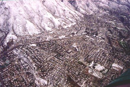
This meant we came over the top at 12,000 feet or so - we had to spiral down
over the suburbs of Salt Lake City as approach wanted us east of the
interstate until we were at 6000 MSL. The landing at Salt Lake City
Municipal Number Two (or just Number Two as the locals called it) was
uneventful. It turned out that our timing with the weather was perfect -
we arrived in good weather, and it snowed overnight and during the next
morning. This made for a good Easter weekend's skiing at Alta and Brighton!
It wasn't long after this that we started getting over really
high ground - over mountains themselves rather than just flying near them.
The view was breathtakingly beautiful, as we detoured slightly, overflying
the Alta and Brighton (photo above right) ski areas,
and then down into Salt Lake City itself.
This meant we came over the top at 12,000 feet or so - we had to spiral down
over the suburbs of Salt Lake City as approach wanted us east of the
interstate until we were at 6000 MSL. The landing at Salt Lake City
Municipal Number Two (or just Number Two as the locals called it) was
uneventful. It turned out that our timing with the weather was perfect -
we arrived in good weather, and it snowed overnight and during the next
morning. This made for a good Easter weekend's skiing at Alta and Brighton!
The day dawned clear and cloudless, with light winds forecast
for our entire route. We decided that instead of flying back via ABQ, we
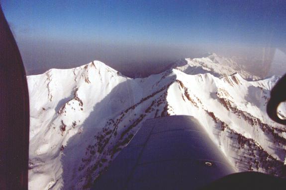
would go a more direct route - directly over the Rockies. From Salt
Lake City, you are in the mountains immediately.
Despite being 5,000 above sea level, the Tiger performed well
since the air was still cool. Very shortly after getting airborne, we were
over the mountains. With a forecast for fairly calm winds aloft and clear
skies, it would be a good flight for us, especially since this was only
our second time flying over high terrain. We had to do some sightseeing too -
although Paul is moving to Salt Lake City and will be living at the base
of these mountains, I seldom see more than a slight hill, so I needed to
savour the moment. The only thing wrong with the weather was that it was
uncharacteristically hazy for the west. The haze we saw was normal for
Houston, but so I'm told, it was very bad for this part of the world.
It's quite odd to be flying at over 11000 feet and having the
terrain only about 1000 below you. It also makes you think where exactly
you'd put it if you had to do a forced landing. There were a surprising
number of options (more than I expected), although some of the options looked
rather rougher than others.
Raton, New Mexico was our first stop. It's over on the east
side of the Rockies (which we crossed in one jump), and seemingly in the
middle of nowhere. The wind had picked up quite a lot too, and it got
fairly turbulent as the wind passed over the various mesas. Our ground
speed seemed very low when we touched down, and the wind at the surface
was about 90 degrees different to what it was aloft. The airport had
food, so we had lunch there. The unicom lady cooked lunch for us!
The next leg was to Mineral Wells, Texas. We climbed up to
11,000 feet again, and the flight went uneventfully for about an hour
or so. After this, the clouds began to build up beneath us, until we
were over an undercast. I checked the weather for airports ahead of
us, and there were a lot of reports for "overcast", so I got a pop-up
IFR clearance as we entered the airspace that's controlled by Amarillo
Approach. Filing IFR turned out to be unnecessary in the end as our
destination was under clear skies, but I got a little bit of "actual"
IFR time when ATC had to keep us below an active MOA. The bad weather news
was received when we were going to leave Mineral Wells. A stationary front
had been true to its name - and had remained stationary. It was the same
front that we had departed under early on Friday morning. However, instead
of benign, smooth IMC conditions, air was moving southwards and being
forced aloft, causing severe thunderstorms. I had seen the front was still
there as we had departed Salt Lake City, so I was planning to file IFR
for the last leg, but the thunderstorms put an end to that plan.
All the severe thunderstorms were concentrated around Houston.
We had travelled around 1,000 nautical miles, to be stopped dead in the last
80 miles! Interestingly enough, the report for golf-ball sized hail was
a PIREP. I'm glad I wasn't the pilot making that report. I decided
to file IFR to College Station which was thunderstorm free. Our flight
to College Station was indeed nice and smooth, and only in occasional IMC.
Ahead of us, we could see the white tops and castellations of the broiling
thunderstoms as they tore through Houston. There were several classic
anvil heads. The landing at College Station was uneventful, and we taxied
in to join half a dozen others who had also been stopped by the storms.
 Fortunately, College Station has good facilities and a nice
pilot's lounge. We had some dinner from the local Chinese takeaway, and
finally launched VFR at around 9pm. In retrospect, we should have filed,
there was an awful lot of scud around. I knew there was something unusual
about our departure because we couldn't see the glow of Houston, normally
visible for miles. This was because sheets of scud blanketed the city, dark
and black. The air was very humid. Travelling through the I-10 corridor,
I requested higher to get above it, and the request was granted. Ellington
was not reporting a ceilling though, but I was a little skeptical. We were
at 2500 ft, about 1000 feet above a solid layer of cloud. ATC turned us
south just as I was about to request a pop-up IFR clearance. However, I
didn't bother in the end as I could see that the scud layer ended near
Ellington, and I could see the beacon at Houston Gulf.
Fortunately, College Station has good facilities and a nice
pilot's lounge. We had some dinner from the local Chinese takeaway, and
finally launched VFR at around 9pm. In retrospect, we should have filed,
there was an awful lot of scud around. I knew there was something unusual
about our departure because we couldn't see the glow of Houston, normally
visible for miles. This was because sheets of scud blanketed the city, dark
and black. The air was very humid. Travelling through the I-10 corridor,
I requested higher to get above it, and the request was granted. Ellington
was not reporting a ceilling though, but I was a little skeptical. We were
at 2500 ft, about 1000 feet above a solid layer of cloud. ATC turned us
south just as I was about to request a pop-up IFR clearance. However, I
didn't bother in the end as I could see that the scud layer ended near
Ellington, and I could see the beacon at Houston Gulf.
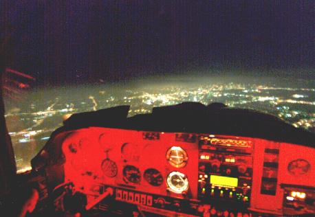
The landing at Houston Gulf in the wet, clammy air was smooth.
The Tiger, however, decided to add some humiliation to the mix. The left
brake got stuck on as I tried to taxi off the runway. We ended up doing
a 360. Fortunately no one was watching! An inauspicious ending to a long
and enjoyable cross country ;-)
[Back to Flying]
Photographs by Paul Reinman and Dylan Smith.