|
TRIP REPORT: SAN MARCOS & CANYON LAKE |
31st May 1998
Time logged 4.1 hours in the C172 - N1219F
Things have been sparse, cross country wise for quite a while.
I hadn't seen a hill from aloft for around 9 months. I had been trying to
go for a good cross country trip for a while, but the smoke from Mexico had
put an end to that. This weekend, however, we got a brief reprieve from the
smoke as the weather patterns changed, moving it over the Pacific. It was
a pleasant change to see blue sky instead of white (or at the peak of the
smoke) slightly yellow skies.
I left SPX in the late morning after crewing a friend's hot
air balloon at the rocket park in NASA. It was a steaming hot day - the ground
temperature was in the mid 90's. After takeoff, I called Houston Approach
and got cleared though the class B. This let me climb and obtain nature's
great airconditioner called alititude. Rather than being stuck down at 1500
ft to remain below the 2,000 ft ring of the class B, I was in it, climbing
steadily to 4,500 ft as approach cleared me higher in steps. When I was handed
off to the west side of Houston Approach, I realised I was fortunate and
had got into his sector from a quieter place. The controller for the sector
was refusing other VFR flights clearance through the class B airspace because...
well, to put it mildly... he was busier than a one-legged man in an ass-kicking
contest! I made sure I stuck to my heading and kept my altitude nailed whilst
transiting his airspace so I wouldn't be any workload on him. I wasn't too
surprised when the second I left the class B I got
"CessnaoneninerfoxtrotradarserviceterminatedsquawkVFRfrequencychangeapprovedgoodday"
gabbled at me at about Mach 2. The controller was well practised at speaking
without putting spaces or punctuation in his sentences!
I continued on, counting off airports and checkpoints
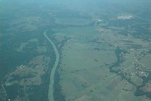
from my chart as I approached Eagle Lake VOR. Shortly I was crossing Interstate
10. I know on the ground this area looks as if it's getting hilly, but from
altitude it looked as flat as the rest of south east Texas - like a billiard
table. At this point I crossed the Colorado River (it's not the Colorado
everyone else knows). It's called the Colorado because this means colored
red in Spanish. This isn't very accurate in the dry season, it's actually
green.
Other people were having their fun in the sun too. You
could see boats on the river, and occasionally I would see another aircraft.
This was the chart change point too, so I moved to the San Antonio sectional
chart which I already had folded to the right place. I used the 274 degree
radial off Eagle Lake and a good dose of pilotage to navigate. Pilotage at
this stage was fairly easy - just keep Interstate 10 a few miles on the left,
and look out for some of the small lakes and airports.
Approaching San Marcos, I got the AWOS frequency (thanks to
the 172's King radios, I actually had all the frequencies I needed tuned
in, so with the exception of an unexpected handoff whilst passing through
the class B, I didn't need to actually turn knobs). As I had expected, winds
were largely favoring runway 22. Listening into the CTAF frequency, I could
tell that this was the case. They did shift a bit, and there was a brief
spell when I was listening that people started using 17. However, the crosswind
was never great for 22, so I decided that I'd use it when I got there since
it is easier to get to the ramp from runway 22. I made little bit of a boob
when coming in - I nearly got ready to set up for a right hand pattern for
22 after checking the windsock, but I caught myself before making any turns
and got set up for the left hand pattern.
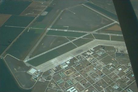 San Marcos Muni used to be an air force base. It's now a
well-equipped non towered field, complete with 2 ILS approaches (you can
see where the array of lights for the "rabbit" for one of the approaches
in the left of the picture). As I went round the pattern, I saw what I thought
was new hangar construction on the ramp. It turned out to be covered parking
for aircraft (not quite hangars) with a couple of dozen aircraft parked
underneath. There were about 20 other aircraft on the vast ramp area near
Berry Aviation. The FBO has quite a bit about how Berry Aviation has grown.
It was started by one man who started a charter business about 15 years ago
in an old Piper Seneca. It has now grown to include fuel, aircraft sales
and other aviation related businesses. The FBO offices were modern and well
kept, and the service friendly and courteous. Even the food simulators (vending
machines!) were inexpensive, so I got myself a Coke and a pack of crisps.
The funny thing was is one of the linemen asked me if I was here the other
day. That's the second time in the Austin area that I have been asked if
I was in such-and-such a place recently that I wasn't. Perhaps I have a twin
wandering around that town or something.
San Marcos Muni used to be an air force base. It's now a
well-equipped non towered field, complete with 2 ILS approaches (you can
see where the array of lights for the "rabbit" for one of the approaches
in the left of the picture). As I went round the pattern, I saw what I thought
was new hangar construction on the ramp. It turned out to be covered parking
for aircraft (not quite hangars) with a couple of dozen aircraft parked
underneath. There were about 20 other aircraft on the vast ramp area near
Berry Aviation. The FBO has quite a bit about how Berry Aviation has grown.
It was started by one man who started a charter business about 15 years ago
in an old Piper Seneca. It has now grown to include fuel, aircraft sales
and other aviation related businesses. The FBO offices were modern and well
kept, and the service friendly and courteous. Even the food simulators (vending
machines!) were inexpensive, so I got myself a Coke and a pack of crisps.
The funny thing was is one of the linemen asked me if I was here the other
day. That's the second time in the Austin area that I have been asked if
I was in such-and-such a place recently that I wasn't. Perhaps I have a twin
wandering around that town or something.
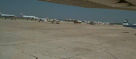
The baking hot ramp included some turboprops, assorted Pipers, Mooneys
and Cessnas that included a Tri-Pacer and a Skymaster.
After paying for the fuel top-off and quaffing the Coke,
it was time to do a little local sightseeing. This really is the gateway
to the Hill Country around San Antonio. As you pass San Marcos itself, it's
like there is a line drawn on the landscape. You go from farmer's fields
and a billiard table flatness to scrubby terrain with lots of hills, mesquite
and prickly pears. The terrain rapidly rises from a flat 590 feet to a hilly
1000 feet level. Canyon Lake itself is about 940 ft above sea level. This
is the first time I've seen the ground rise underneath me whilst maintaining
my altitude. You can tell I'm a flatlander. It was quite surprising at first.
I knew it would, but it was sort of different to see it actually happen.
Every so often, a thermal would start the plane climbing. I didn't correct
for this - I let the thermals give me a free ride higher. I climbed pretty
well at some spots without pushing the throttle in. At one point I was half
tempted to pull the engine to idle and slow the aircraft down to see if I
could thermal like a glider - I think it would have been possible since some
of the thermals would give me a brief 500 fpm climb at cruise speed. It was
really hot here - the San Marcos AWOS had been reporting 37 degrees
Celcius.
I also wanted to take a look at the Canyon Lake airport. It's
private, but the AOPA directory lists a phone number for it so I'll have
to call and see if they let any old spam-can use it. A friend from work has
family there, and I've gone down to Canyon Lake once or twice on a long weekend
trip. To fly there would be a great added bonus since it's so close from
where they live. It looks like a decent 2,200 ft paved runway, with the caveat
painted on the hangar roof "Deer on the runway". I guess you have to make
a low pass once to scare them all off.
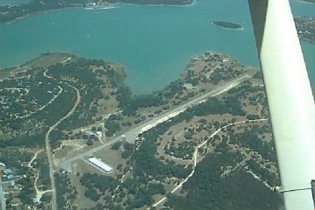
The small Canyon Lake airport even has run-up pads.
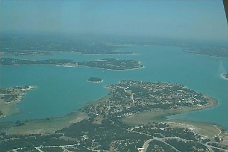
The lake is actually artificial - it's where the Guadalupe
River was dammed many years ago. You can see trees sticking through the water
in places. After the dam, the Guadalupe runs cold and rapidly. You can rent
an inner tube and go tubing on it. It's a fun ride on a hot summer's day!
Lots of people were out on boats on the deep sea green water.
Another view of the lake, looking towards the dam in the distance.
Heading for home, I went back over the San Marcos airport and
followed a near reciprocal path (a little further to the south than I had
come in on). Someone had squawked the plane for being out of rig, so once
set up for a nice cruise, I took my hands and feet off the controls to see
what happened. It kept flying perfectly straight and level with the ball
centered. I guess once you come up to a good cruise speed (something that
doesn't always happen on local flights) it's rigged pretty well.
Reaching the Colorado river again, I saw a sharp meander in
the river. At some point it would turn into an oxbow lake, the houses in
between where the river wants to really run will probably be in trouble.
Nature always wins because nature doesn't care about taxpayer's money and
is a damned sight more patient than most people. However, it'll probably
take many decades for it to happen. You could see the sandbanks on the inside
of the corners of the river as the river inexorably changes its path over
the years towards the opposite side of the meander. The interstate and railway
lines also crossed at this point, and a train about a mile long was trundling
westwards.
A little after passing the Eagle Lake VOR, I pressed the button
on the radio and started listening to approach. It was much quieter. Just
under 15 miles from the class B airspace, I called the controller and got
cleared into the class B at or below 4,500 ft. Shortly I was passing the
lake and Houston Southwest airport where I took my checkride that muggy early
October day. With these thoughts, I was handed off to the southeastern sector
of Houston Approach - a lady who sounded quite like Maybelle Fletcher, the
DE who did my private checkride. The only other traffic was a skydive jumpship.
The jump plane and the controller chatted a little about skydiving. The
controller was a little bit unwilling to jump out of a perfectly good plane!
Once I had SPX in sight, I advised the controller, and went to the CTAF
frequency.
The wind was a bit gusty at SPX and the plane couldn't quite
decide when it was done flying, but other than that, the landing was smooth.
(Oh yes, the two hands on the yoke flare technique I had found worked great
in the Arrow doesn't work that well in a C-172! See my complex checkout pages)
I tied down the plane very satisfied that the navigation had gone spot on,
I had flown somewhere I hadn't flown before, seen some hills, got my radio
procedure right and had a really good flight!
[Back to Flying]
[Home Page]